Rocky Harbour
Exploration Day, Biked 10 miles
Tour Guide Description: We will take a day to explore the National Park, viewing its magnificent fresh-water fjords, and many pleasant trails.
 |
| Sour Bobcats |
 |
| Roger's photo of Kathy, Gleb, Dave, Nancy, Claude, Arlene, and Marshall who hiked to a waterfall from the campground |
 |
| Roger's photo of the view from the campground |
 |
| Internet pix of "The Gulley" up Gros Morne Mountain (806m) and a close-up of the talus trail up the gulley. Ouch! Not the place to be with tendonitis or a game knee on a rainy day |
Instead of the spectacular, we chose the mundane, washing out our ride clothes and “organizing” ourselves for the rest of the morning. With the electrical tape I'd bought at the grocery, I finally taped a bottle cap over my computer button so that I would not accidentally turn it off. Then, out of boredom, I took pix of the wood art that filled the Ocean View’s walls. All were done by the same person, with some running into the thousands of dollars.


 |
| Fisherman next to a line of drying fish |

 |
| A display of handknit quilts and rugs typical of those found in NF homes today |
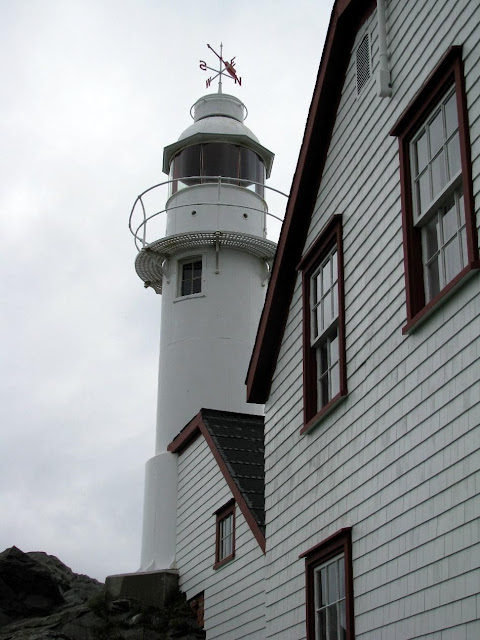
The lighthouse was only about 4 miles away. On my way there, I met Ed in the van. He’d brought some campers down to do their laundry and shop and said that he and Gary would be by about 3 to give us the next day’s daily map and information sheets before returning to the campsite.
(An aside here: Each evening about 7 or so Gary and Ed would appear and knock on our door. They’d come in, and Gary would hand out a route sheet with a map on the back of it, and a second sheet with the place for grocery pickup or suggested lunch stops and “diversions” for the day. He never commented on these sheets or said much of anything — he was often on his cell and “distracted” while in the room, never making eye contact — but he would answer questions if we asked. Up to this point we’ve had very minimal—and very reluctant—support from this group to whom we’ve paid close to $900 to support us.)
After talking to Ed for a bit at the side of the road, I continued on and rode to the lighthouse. Actually rode past it and up a hill to a T-intersection at Hwy 430. Ah so! I had not studied the maps closely so now understood how we would start off tomorrow. By missing the turn to the lighthouse I had seen the light. We would need to ride only the few short miles to NL-430N (the Viking Highway) where we would pick up the other riders on their way down from the campground..
Since I’d ridden a bit past the lighthouse, I retraced and took a right to the lighthouse. It was appropriately in Lobster Cove at the very tip of land at the mouth of Bonne Bay, surrounded by rocky cliffs and a spruce forest. It’s still an operating lighthouse so one could not climb up to the light, but I did walk a trail around it and read the flags that it flew, which in international maritime flag signals spelled “GROUTY,” which this landlubber could not interpret.


When I got back to the motel, I was muddy and wet, so showered, washed my hair, washed out my riding clothes, ate lunch (salmon, cheese & crackers from my food box), and read the last of my book, all of this in silence, trying to avoid interaction with Suz. I then walked to the bank’s ATM for Canadian $. I took a few pix of the area while I was out. Suz is still testy and needs more time alone.


At about 3:30 or 4 pm, Gary and Ed came and handed out their maps and route information. Later that evening we asked at the front desk whether there was a small inexpensive cafe nearby and were told that there was one three doors down above a gift shop. Here we ate dinner. I had delicious codfish au gratin and Suz had fish chowder.


When I got back to the motel, I was muddy and wet, so showered, washed my hair, washed out my riding clothes, ate lunch (salmon, cheese & crackers from my food box), and read the last of my book, all of this in silence, trying to avoid interaction with Suz. I then walked to the bank’s ATM for Canadian $. I took a few pix of the area while I was out. Suz is still testy and needs more time alone.


 |
| Rain's stopped, sun's peeking out; time to get outdoors for a picnic on the beach |
No comments:
Post a Comment